


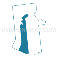
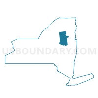
Voting District 010001, Hamilton County, New York
About
Outline

Summary
| Unique Area Identifier | 627397 |
| Name | Voting District 010001 |
| County | Hamilton County |
| State | New York |
| Area (square miles) | 329.41 |
| Land Area (square miles) | 317.18 |
| Water Area (square miles) | 12.23 |
| % of Land Area | 96.29 |
| % of Water Area | 3.71 |
| Latitude of the Internal Point | 43.50018440 |
| Longtitude of the Internal Point | -74.57958830 |
Maps

Graphs
Select a template below for downloading or customizing gragh for Voting District 010001, Hamilton County, New York


Neighbors
Neighoring Voting District (by Name) Neighboring Voting District on the Map
- Voting District 010001, Fulton County, NY
- Voting District 020001, Hamilton County, NY
- Voting District 030001, Fulton County, NY
- Voting District 040002, Hamilton County, NY
- Voting District 050001, Hamilton County, NY
- Voting District 060001, Hamilton County, NY
- Voting District 070001, Hamilton County, NY
- Voting District 070002, Hamilton County, NY
- Voting District 080001, Hamilton County, NY
- Voting District 090001, Hamilton County, NY
- Voting District 120001, Fulton County, NY
Top 10 Neighboring County Subdivision (by Population) Neighboring County Subdivision on the Map
- Indian Lake town, Hamilton County, NY (1,352)
- Caroga town, Fulton County, NY (1,205)
- Lake Pleasant town, Hamilton County, NY (781)
- Long Lake town, Hamilton County, NY (711)
- Wells town, Hamilton County, NY (674)
- Stratford town, Fulton County, NY (610)
- Bleecker town, Fulton County, NY (533)
- Inlet town, Hamilton County, NY (333)
- Arietta town, Hamilton County, NY (304)
- Benson town, Hamilton County, NY (192)
Top 10 Neighboring Place (by Population) Neighboring Place on the Map
Top 10 Neighboring Elementary School District (by Population) Neighboring Elementary School District on the Map
Top 10 Neighboring Unified School District (by Population) Neighboring Unified School District on the Map
- Gloversville City School District, NY (19,244)
- Dolgeville Central School District, NY (5,362)
- Poland Central School District, NY (4,323)
- Northville Central School District, NY (2,981)
- Indian Lake Central School District, NY (1,352)
- Wells Central School District, NY (929)
- Long Lake Central School District, NY (597)
- Inlet Common School District, NY (333)
- Piseco Common School District, NY (307)
- Raquette Lake Union Free School District, NY (114)
Top 10 Neighboring State Legislative District Lower Chamber (by Population) Neighboring State Legislative District Lower Chamber on the Map
Top 10 Neighboring State Legislative District Upper Chamber (by Population) Neighboring State Legislative District Upper Chamber on the Map
Top 10 Neighboring 111th Congressional District (by Population) Neighboring 111th Congressional District on the Map
Top 10 Neighboring Census Tract (by Population) Neighboring Census Tract on the Map
- Census Tract 9705, Fulton County, NY (4,216)
- Census Tract 9704, Fulton County, NY (1,738)
- Census Tract 9503, Hamilton County, NY (1,352)
- Census Tract 9504, Hamilton County, NY (1,269)
- Census Tract 9505, Hamilton County, NY (1,171)
- Census Tract 9501, Hamilton County, NY (1,044)
Top 10 Neighboring 5-Digit ZIP Code Tabulation Area (by Population) Neighboring 5-Digit ZIP Code Tabulation Area on the Map
- 12078, NY (23,773)
- 12134, NY (3,516)
- 12032, NY (836)
- 13470, NY (725)
- 12190, NY (674)
- 12847, NY (605)
- 12108, NY (416)
- 13360, NY (333)
- 12139, NY (295)
- 12812, NY (150)